Sail Route Planning: How to Have Safe And Successful Passages
I love seeing my sailing friends’ updates on all of their sailing adventures. They have sailed the high seas along the east coast of the United States, the Eastern and Western Caribbean, the Azores, and beyond.
But they didn’t just get there on a whim. It takes a lot of sail route planning and preparation to get to where we are going safe and sound.
So, what all is involved in sail route planning for a safe and enjoyable sailing experience? I’ll go over the following key elements to help you with your passage planning for a safe, efficient and pleasurable sailing experience.
Sail Route Planning: 6 Key Elements
1. Where Are You Going? How Will You Get There? How Long Will It Take?
How to plan a sailing route starts with these three questions. Where you are going, and how you plan to get there will help you determine how long it will take. You should know your vessel’s cruising speed, that will then help you determine how long it will take to get there.

For sail planning on our Hunter 450 Passage, we estimate cruising speeds at both 5 and 6 knots, to help us determine a timeframe for our arrival.
How you get to your destination will play a big factor in how long it will take to get there. If you are planning to take the Intracoastal Waterway (ICW) and anchor each night, it will take you much longer than sailing offshore to your destination.
For example, we were going from St. Augustine, FL to Titusville, FL just last month. We wanted to sail offshore from St. Augustine to Cape Canaveral, then go up the ICW to Titusville, which would take us approximately 25 hours. However, due to the weather conditions offshore (more on this topic shortly), we took the ICW south to Titusville. It is important to have an emergency anchorage in passage planning as well as alternative routes in mind.
Due to all the bridges we had to go through, and higher than high water levels, we had to break this trip up into three separate days.
To read more about how we got through this stretch of the ICW with our 63-foot mast during higher than high tides, read Florida ICW by Sailboat: Stressful Sailing Under 65-Ft Bridges.
It is important to know approximately how long your passage will take, so you can factor in things such as arriving in daylight vs night time, and tides and currents where you will be arriving.
We try to time up our passages so we can arrive during daylight hours, especially if it is a place we have never been to before.
When we crossed the Mona Passage, for example, we left the Dominican Republic in the early morning hours, so we could arrive in Puerto Rico the next morning in daylight hours. We also did this to avoid the afternoon thunderstorms in Puerto Rico!
Sometimes, that is not always possible, given the length of the passage. In these cases, we prefer to set a departure time to leave in the dark and arrive in the light, rather than leave in the light and arrive in the dark. However, ultimately, it is a case-by-case basis, and things you should consider when planning your passage.
2. Navigation / Charts
There are wonderful sailing navigational tools and chart plotters out there that can help you with your sail route planning. Navionics has a sailing route planner / boat trip planner that allows you to plug in your departure location and arrival destination, and it will route your path for you.
Pay Attention and review the route carefully before leaving!
We have seen these nautical route planner tools route passages over plane wrecks and navigational aids out in the middle of the water.
These sailing trip planner tools also route passages based on your sailboat data that you enter. While you may be able to squeak by through a narrow cut with the draft you entered in the tool, we tend to be more conservative and will take slightly longer, but deeper routes along the path to err on the side of caution.
An example of this is when we sailed from Meek’s Patch in Northern Eleuthera to Little Harbour Cut in the Abacos, Bahamas. There is a route north of Meek’s Patch locally known as the devil’s backbone that we technically could make it through. However, it is known for its shifting sands and recommended to use a local pilot just to get through this area. We opted to sail west around Egg Island, before heading north to the Abacos.
3. Weather: Wind And Waves
The weather forecasts also play a very important factor in sail route planning. As I mentioned above, when we were in St. Augustine, we wanted to sail offshore to Cape Canaveral, then work our way back up to Titusville. However, there was a low-pressure system offshore that was creating 8–10-foot waves with short periods that would make for a very uncomfortable ride.

We use many tools as mentioned in our favorite weather apps article, to help us with the weather predictions. The best sailing route planning software, and one of our favorite services we subscribe to, is PredictWind. PredictWind has many features that I love, but specifically, it has two sail routing planning features (available on the Standard plan here) that I find very helpful:
Sail Departure Planning
The Sail Departure Planning feature in PredictWind averages data from four different weather models and provides a lot of useful forecasted information including the following listed below. It also maps out the route for 4 different departure days for you to compare.
- Passage time
- Maximum, minimum, and average wind speed
- Maximum gusts
- Maximum CAPE
- Maximum rain
- % time upwind
- % time reaching
- % time downwind
- % time in various brackets of wind speed
- % time in less than 1-meter waves, 2–3-meter waves, etc.

Sail Weather Routing
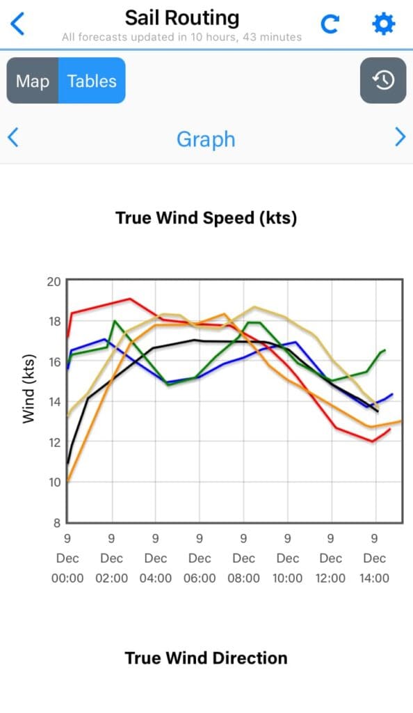
The best sailing weather routing app we have found is the Sail Weather Routing feature in PredictWind. It is an excellent tool to use once you have determined a good departure date and time from the Planning tool.
It provides graphs of the various weather models for the following:
- True wind speed
- True wind direction
- True wind angle
- Rain (inches/hr)
- CAPE (j/kg)
- Temperature
- Barometric Pressure
- Wave height (this one has different settings; we have ours set to Combined Wind Wave & Swell)
- Wave direction
- Wave period
We are currently trying to plan a passage from West Palm Beach to Grand Cay, Bahamas. However, it is December and there are cold fronts after cold fronts with north winds currently passing through. To get to Grand Cay, we must cross the Gulf Stream. As many of you know, you shouldn’t cross the Gulf Stream with a northly wind component. This will make for very choppy and rough conditions.
Tip
When planning for a departure, we write down each day what the forecasted modules say from our weather tools. By doing so, we can track if the forecast is staying consistent (always a good sign), or changing for better or worse. This is very helpful when making our decision for a larger crossing, such as crossing the Gulf Stream to the Bahamas.
4. Tides And Currents
Tides and currents can have a great effect on your sail route planning. They can speed up your trip, slow your trip down, or even not allow you to pass under fixed bridges, as we ran into during our sail down the Florida ICW.
ICW Planning With Tides And Currents
Going up and down the ICW involves a lot of planning with passing through bridges that open on a schedule, or passing under fixed bridges.
Pelagia, our Hunter 450 Passage, has a mast height of 63-feet, and an antenna, mast light and wind vane on top of it barely passes under the several 65-foot fixed bridges (and one 64-foot bridge in North Carolina!). It’s nearly impossible to pass under them all at low tide, and on a couple of occasions our antenna has tinged the bottom of the bridge!
The currents can speed you up or slow you down, which impacts when you arrive at bridges for their scheduled openings. It can be a bit challenging trying to wait for a bridge opening with a current pushing you toward the bridge.
Offshore Planning With Tides And Currents
One of the places tides and currents really come into play with offshore planning is at your departure and arrival inlets. Some inlets, or channels, are wide and deep and easy to navigate. For these inlets, the tides and currents have less of an impact. However, others are not so wide.
The narrow channels lined with jetties really enhance the effects of the currents when you are trying to go in or out of the channel. Add onto that what the wind is doing, and it can be a very rough portion of your trip.
For example, you should avoid a strong ebb (outgoing) current at an inlet when the wind is blowing into the inlet because the offshore waves will become very tall and steep at the inlet making for a hazardous passage. In this case it is best to enter with a flood tide, which will provide calmer conditions and make the transit into the harbor faster.
The Gulf Stream is a strong and fast current that runs north along the eastern United States between it and the Bahamas. When crossing the gulf stream, any northerly wind against this strong north current is a recipe for disaster.
Lastly, even on an offshore passage, the tides and currents (along with the wind and the waves) in the area you are traveling can have an impact on your speed and estimated arrival time. We have found that the offshore current information available in AquaMaps is quite helpful in determining how the offshore currents may affect our passage.
5. Safety And Emergency Planning
Safety should always be at the forethought of your sail route planning to have a safe sailing experience. Whether you are traveling down the ICW or traveling offshore, safety planning and emergency prevention is key to an enjoyable sailing passage.
Make sure you inspect all your safety gear, such as life jackets, Garmin InReach, ePIRB, VHF radio, charts, etc. and they are all in good working order and easily accessible to have a safe sail.
On offshore trips such as our overnight sailing trips, we always put out our jacklines to have something to tie off to in the event we need to go outside of the cockpit.
An easy way to remember all of your safety checks and preparations for your passage is to write it down in a checklist. I have a Pre-Departure Checklist we use before each passage that helps take the stress out of worrying if I remembered everything. Get a copy of our Pre-Departure Checklist below. It’s free, editable and available offline:
6. Executing The Passage – Snacks, Medications, Etc.
Let’s not forget about making the trip comfortable for all passengers! And by that, I mean snacks! I always try to have easy meals and snacks at the ready because even with all your planning, the weather will do what it wants to do, which may not be exactly as forecasted.

If you are prone to seasickness, be sure to take your medications as directed. For me, if the forecast calls for following seas, I will take my sea sickness medications about an hour before our trip. I’ve learned the hard way too often by not taking it ahead of time :/
Another step I take for ensuring a pleasant trip is setting up our watch rotations well before the evening hours if doing an overnight sail. This allows each person to take a nap or mental break during the day and be more well-rested for the nighttime watch.
I use this list to help me prepare ahead of our passage:
- Make snacks and easy to grab meals
- Make coffee and put in thermos for overnight passages
- Download audiobooks and podcasts for longer passages
- Take seasickness medicine an hour before departure
- Secure all items inside and on deck. Even if you aren’t expecting rough seas, expect the unexpected!
- Put all items in cockpit before departure:
- Tablet
- VHF radio repeater
- Cushions/chairs
- Cell phone holders & cell phones
- Cell phone chargers
- Water bowl filled for Mangaux
To see more of what’s on our Pre-Departure Checklist, get a free copy you can edit yourself here:
Summary
Heading out on a sailing trip takes lots of planning and preparation. Whether you are out for a day sail, cruising down the ICW, or venturing offshore, it is important to be aware of the weather, tides, currents and use your sailing and navigational tools to help you have a safe and enjoyable sail.
I would love to hear what you find to be the best sail route planning tools to use and steps you take to plan a safe passage. Reach out to us on Facebook and Instagram and share your sailing adventures!
Learn More Sailing Tips Here:
- PredictWind Review: Pros, Cons & Real Use at Sea
- 12 Essential Subscriptions Used When Boating as Full-Time Sailors
- Favorite Weather Apps For Sailing: Discover The Best Features
- Crossing The Gulf Stream: 4 Proven Tips From A Coast Guard Veteran
- Sail Route Planning: How To Have A Safe And Successful Passage With These 6 Key Elements
- Sailing at Night: Top 10 Tips in the Helpful Guide
- Sailing with a Dog: Practical Guide for Cruisers
- Sailing with a Dog in the Caribbean: Ruff Times?
- 10 Things to Know about Cooking on a Sailboat
