Sailing the Gulf of Mexico: Mobile, AL to Key West, FL
We cast off lines and took off for our adventure in January 2022 after 6 years of planning. Our plan at the time was sailing the Gulf of Mexico along the gulf coast east across the panhandle and then south to Key West. We will be stopping at anchorages and marinas along the way.
From there, we would spend some time in the Florida Keys, before making our way over to the Bahamas, then back to the United States and travel up the east coast for hurricane season. If you are interested in learning how we provisioned for the Bahamas, and the cost of groceries over there, check out Helpful Tips for Provisioning for the Bahamas. This article will cover our travels from Mobile, AL to our arrival into Key West, FL.

Mobile, AL to Gulf Shores, AL – Sailing the Mobile Bay
Right out of the gate, we ran into weather delays. We set our departure date for January 20, 2022. Our big day was upon us, only to be met with astronomically lower than low tides and north wind pushing the water level lower. We were unable to leave the dock until 2:00 PM due to the low water levels.
Our original plan was to make it to Ingram Bayou along the Intracoastal Waterway (ICW) in Alabama, approximately 37 nautical miles (nm). However, due to our late start and shorter days in January, it was dark by the time we got through the Mobile Bay and into the ICW.
We stopped short at 30 nm arriving Homeport Marina for the night. There is a lot of barge traffic in the area of the ICW and we weren’t comfortable yet transiting and anchoring at night.
Homeport Marina
- Latitude: 30° 16’ 49.86”N, Longitude: 87° 41’ 07.31”W
- Cost: $2.50 per foot per day for transient
- Slips: Floating
- Power: Included in cost (30, 50 and 100 amp)
- Water: Included in cost
- Laundry: one washer and one dryer on-site. If I remember correctly the cost was reasonable around $1 to $1.25 per machine.
- Bathrooms/Showers: Yes, door has code and they were very clean.
- Pet Friendly: Yes
- Groceries: Publix 1.5 miles away
- Restaurants: Yes – Lulu’s Restaurant on-site
Gulf Shores, AL to Pensacola, FL – Cruising the ICW
The next day we motored our way along the ICW past Orange Beach and Perdido Key to the Fort McRee anchorage in Pensacola, FL, traveling 20.8 nm. This is a protected anchorage with sandy beaches all around that our dog Mangaux loved to run around on. Read more here about living with a dog on a sailboat.
We anchored here for two nights, and this was the start of the numerous bad storms we would encounter all the way down the coast. On our second night at anchor, we withstood 40+ knot winds around 2:00 AM. After that night, and knowing that more cold fronts were coming, we decided to sail up the Pensacola Bay and move to a slip at the Pensacola Yacht Club.
Since we are still members of the Mobile Yacht Club, we receive reciprocating member prices. And since we were there during offseason, they graciously let us stay 3 nights for the cost of 1 night!

Fort McRee Anchorage
- Latitude: 30° 19’ 38.82” N, Longitude: 87° 19’ 10.21”W
- Holding: Sandy bottoms – great holding as we didn’t drag in 40+ knot winds
- Wind Protection: Protection from North, East and South
- Depth: 10-14 feet
- Pet Friendly: Yes
- Groceries: None nearby
- Restaurants: None nearby
Pensacola Yacht Club
- Latitude: 30° 23’ 57.60”N, Longitude: 87° 14’ 21.00”W
- Cost: $80/night (membership required)
- Slips: Floating
- Power: Yes – Included in cost
- Water: Yes – Included in cost
- Laundry: Yes – 1 washer and 1 dryer for free!
- Bathrooms/Showers: Yes, clean and good water pressure
- Pet Friendly: Yes – large grass lawn
- Groceries: Publix 3.1 miles away (ride share recommended) Restaurants: Yes – restaurant on site and additional restaurant withing walking distance
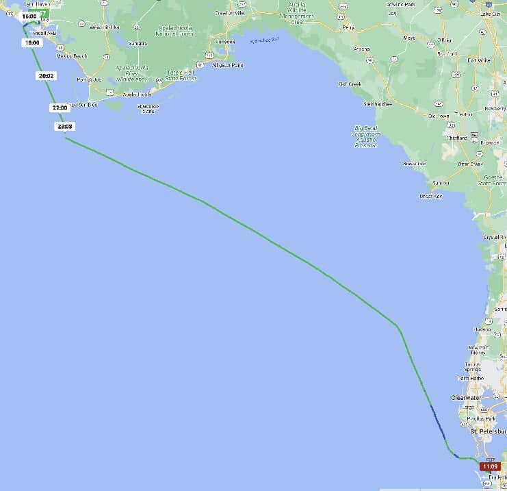
Pensacola, FL to Panama City, FL – Sailing the Gulf of Mexico


Our original plan was to move back down to the Fort McRee anchorage 9 nm from the Pensacola Yacht Club and stage for our next passage. Our mast height is 63 feet, so we are too tall to go any further down the ICW from Pensacola. We planned to leave the next morning and go in the open water to sail the Gulf of Mexico to Port St. Joe, FL.
On our way down to the Fort McRee anchorage, we checked the weather again and decided to go straight to Port St. Joe instead of waiting until the next day. BIG MISTAKE!
The weather forecasts said winds up to 20 knots out of the north. What we actually saw in the middle of the night was sustained winds over 35 knots!
The waves were crashing over the bow while the winds were coming out of the north. It made for some very rough and choppy seas. The conditions actually flung one of our 5-gallon diesel cans off the side of the boat (it was saved and dangling by a bungy cord) and sheered the fishing rod holder that our grill was in right off!
In the middle of the night, Scott made the decision to turn north and head for Panama City instead of Port St. Joe. One hundred and seven nautical miles later, we arrived in Panama City.
We dropped anchor at Redfish Point to get a couple of hours of sleep and regroup. Checking the weather again, and it being the middle of winter, we had yet more cold fronts heading our way.
Still being a bit rattled from our overnight passage (Scott has done several overnight passages in the USCG, however, this was my very first one, and one that I will never forget!) we moved up to Watson’s Bayou and stayed at Emerald Harbor Marina to wait out the next cold front. The manager of this marina is a friend of a friend of ours, and Seth was more than accommodating, helping us in the slip and even offered his truck if we needed it!
Redfish Point Anchorage
- Latitude: 30° 08’ 20.10”N, Longitude: 85° 40’ 05.10”W
- Holding: Mud – good holding
- Wind Protection: Protection from the south and west
- Depth: 10-15 feet
- Pet Friendly: Yes
- Groceries: None nearby
- Restaurants: None nearby
Emerald Harbor Marina
- Latitude: 30° 09’15.84”N, Longitude: 85° 38’ 15.07”W
- Cost: $2 per foot
- Slips: Fixed docks (new after Hurricane Michael)
- Power: Yes – Included in cost
- Water: Yes – Included in cost
- Laundry: Yes – 1 washer and 1 dryer for free!
- Bathrooms/Showers: Yes, bathrooms were good; we did not use the showers
- Groceries: Nearest grocery store was ~5 miles away
- Restaurants: 1 nearby; other restaurants were near the grocery stores ~5 miles away
Panama City, FL to Tampa Bay, FL – Sailing the Gulf of Mexico
After we recouped and waited for a really good weather window, 3 days later we were on our way again headed south to Tampa Bay area. We went offshore for 249 nm arriving in Tampa Bay two days later.
The entire passage was flat calm (a welcoming site after our last passage, even though we had to motor the entire way), but also very foggy. We put our radar in good use to keep an eye out for oil platforms and fishing and shrimping boats while sailing the Gulf of Mexico. We also spotted a large pod of dolphins and other marine life such as jelly fish and Portuguese man o’ wars.
After arriving in Tampa Bay, we made our way a short distance up the Manatee River and dropped anchor at Desoto Point (Holy Hole) in Brandenton, FL. We really enjoyed this anchorage as, you guessed it, we waiting out the next cold front for the next 5 days. The weather gave us the opportunity to meet up with sailing friends who moved to the Tampa area while we were here.

The Desoto Point (Holy Hole) anchorage is located immediately adjacent to the Desoto National Memorial Park with a great trail to walk our dog. It was also only a 2.5 mile walk to Publix.
Desoto Point (Holy Hole) Anchorage

- Latitude: 27° 31’ 21.60”N, Longitude: 82° 38’ 29.11”W
- Holding: Mud – good holding
- Wind Protection: Protection from Southeast through West
- Depth: 10 feet
- Pet Friendly: Yes. While you cannot bring your dinghy up to the shore at the Desoto Memorial Park, it is immediately adjacent to a public beach where we brought our dinghy to. The Desoto Memorial Park is connected with a trail to the public beach.
- Groceries: Yes – 2.5 miles through a very nice neighborhood to the Publix
- Restaurants: Yes – same general area as groceries
Tampa Bay, FL to Longboat Key West of G15 Anchorage – Cruising the ICW

After spending several passages sailing the Gulf of Mexico, we decided to check out the ICW along the west coast of Florida.
After the first hour or so, we both decided we prefer to be offshore! The depths were very shallow, and we couldn’t get to a couple of docks for fuel due to these shallow depths (luckily we were still about ½ full).
We traveled 18.5 nm and anchored for the night at Longboat Key South Anchorage, just north of the Ringling Bridge in Sarasota. It was a bit exposed, but we had calm weather. It was also a bit of a dinghy ride to find shore access to take Mangaux for a walk. We ended up tying up to a dock at a condo complex, where we got called pirates when spotting going to shore there!
Longboat Key West of G15 Anchorage
- Latitude: 27° 23’ 04.80”N, Longitude: 82° 37’ 01.79”W
- Holding: Good – sandy bottom
- Wind Protection: Protected from south through west winds
- Depth: 6-12 feet
- Pet Friendly: We made it work, but not really pet friendly
- Groceries: Publix located on Longboat Key
- Restaurants Nearby: Yes
Longboat Key West of G15 Anchorage to Venice, FL – Cruising the ICW
Our next stop was 20nm south to Venice, FL. The water has been getting clearer and clearer as we have been headed south, but when we hit Venice, it was a turquoise beautiful color. We discovered that this section of the ICW is very shallow, bumping the bottom twice with our 5.5’ draft. Near Venice, there was not much for anchorages, so we stopped at the Crow’s Nest Marina for 2 nights. This also allowed us to get some laundry done and explore the town. We really enjoyed our stop at this marina and the town of Venice.
Crow’s Nest Marina
- Latitude: 27° 06’ 43.02”N, Longitude: 82° 27’ 53.99”W
- Cost: $3.22 per foot (most expensive marina we have stayed at, including the Florida Keys, Bahamas, and east coast of the US).
- Slips: Fixed docks located just inside the Venice Inlet
- Power: Yes – Included in cost
- Water: Yes – Included in cost
- Laundry: Yes – $2.75 per machine
- Bathrooms/Showers: Yes, separate rooms with toilet, sink and showers. Nice, clean and good water pressure
- Pet Friendly: Yes – Park right next door that you can walk your dog to.
- Groceries: Yes – Publix approximately 2.5 miles away
- Restaurants: Yes – 2 restaurants on-site
Venice, FL to Boca Grande, FL Anchorage – Cruising the ICW
We had another cold front headed our way, but we were advised not to stay at Crow’s Nest Marina due to their exposure to swells at the Venice Inlet and the strong forecasted westerly winds. So, on we went south.
There are not many protected anchorages that we felt comfortable getting into with our 5.5 foot draft, so we went 28.5 nm south to Boca Grande, FL. We anchored just south of the Boca Grande Yacht Basin Channel to wait out the strong westerly winds coming our way.
However, first we had to sit through some strong southerly winds, which cranked up to mid-30 knots. Days like these make it very challenging to get the dog to shore. We also learned this anchorage gets A LOT of boat wakes from the Boca Grande Yacht Basin Channel.

Boca Grande Anchorage
- Latitude: 26° 44’ 48.74”N, Longitude: 82° 15’ 06.14”W
- Holding: Sand shells – Good holding
- Wind Protection: Only protection is from the west
- Depth: 9 feet
- Pet Friendly: Yes – There is a dock near the Pink Elephant restaurant on Gasparilla Island that we tied our dinghy up to.
- Groceries: No grocery stores on Gasparilla Island
- Restaurants: Yes, several within walking distance on Gasparilla Island
Boca Grande Anchorage FL to Key West, FL – Sailing the Gulf of Mexico
We didn’t want to travel any further south down the ICW as we were getting closer and closer to Fort Myers, where Hurricane Ian hit in September, just 5 months prior. There are reports of navigational hazards with a lot of debris still in the water. We also wanted to get out of the ICW at this point with the shallow channel and lots of bridges to go through. That meant going offshore and sailing across the Gulf of Mexico to Key West, FL.

There weren’t many great weather windows coming up, but we also wanted to get out of this bumpy anchorage in Boca Grande. So when we felt we could manage the conditions, we made a run for it.
We had NW to NE winds at 10-15 knots with a westerly swell from the previous front giving us quartering seas for the transit. This made for a very rolly ride. About 12 hours into our 24 hour passage, my stomach had enough of the motion, and overboard went my dinner (and lunch and breakfast).
It wasn’t a frightening passage, just uncomfortable. Once we got into Key West Channel, 24 hours later, we had a pleasant sail in blue skies and felt we finally arrived to where we wanted to be and closer to the Atlantic Ocean.
Conclusion
Sailing the Gulf of Mexico from Mobile, AL to Key West, FL was a bit of a challenging one considering we made the trip in January and February. This is the time of year that the winter cold fronts pass through on a frequent basis. Finding protected anchorages at adequate depths (with dog access) was more challenging that we realized. Therefore, we spent more time at marinas than we anticipated. We also realized that we needed a mental break from time to time with all of the cold fronts passing through every 3-5 days.
We originally planned to sail out to the Dry Tortugas, however, it would be an overnight passage there and back to get there. We decided after waiting out all the cold fronts to get down here to just take it easy for a while and enjoy the Florida Keys.
On this first major leg of our adventure, we traveled a total of 628.4 nm in 26 days sailing the Gulf of Mexico. We spent a total of $943.94 in marina fees to get from Mobile, AL to Key West, FL. We filled our diesel tank up one time in Venice, FL with 62 gallons, costing us $404.56. Read here about our sailing budget expense categories and how we did on our budget on our first 6-months out.
This can be done much quicker and cheaper with a direct route, which would require good sailing conditions for the transit. However, we also want to see and do new things on our adventure so while we learned a lot on this first leg we did get time to enjoy some new areas along the way. The next article will detail the next leg of our adventure sailing Key West to Coconut Grove.
Live your dreams,
